
Peatland degradation and trajectories
Analysis of peatland degradation and trajectories using high-resolution spatiotemporal satellite data
The approximately 18,600 km² of bogs and fens in Germany are almost all highly degraded and emit 53 Mt CO₂ eq./year. To counteract further degradation and its consequences, detailed condition assessment using satellite data can serve as a basis for decisions regarding restoration measures and their monitoring. To assess the overall condition of peatlands in northern Germany, a comprehensive land cover system with integrated degradation levels (“Peatland-LC”) is being developed using a multi-stage approach. This system includes the current land cover due to vegetation and land use, as well as the associated emissions, a description of surface properties related to the current hydrological situation and peat condition, and the land use history, presented in an integrated and, where possible, quantitative manner. All necessary parameters can be derived from optical remote sensing data (Sentinel-2 from 2016 and Landsat from 1984). The combination of multi-seasonal information (spectral-temporal metrics and phenological metrics) and machine learning methods allows for a reliable derivation of land cover and land use history and an approximation of the hydrological situation.
- de Waard, F., Krummheuer, Y. (2021): „Moorbrände und Klimawandel“ – Artikel im Jahresbericht biologische Vielfalt Schleswig-Holstein
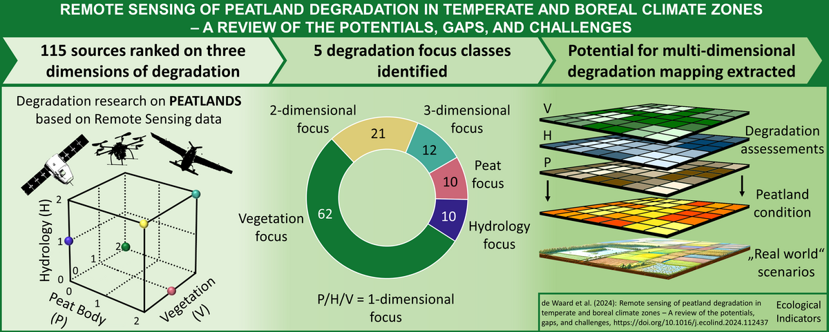
- de Waard, F., Connolly, C., Barthelmes, A., Joosten, H., van der Linden, S. (2024): Remote sensing of peatland degradation in temperate and boreal climate zones – A review of the potentials, gaps, and challenges. Ecological Indicators, https://doi.org/10.1016/j.ecolind.2024.112437
- Pham, V.-D., de Waard, F., Thiel, F., Bobertz, B., Hellman, C., Nguyen, D.-V., Beer, F., Arasumani M., Schwieder, M., Hartleib, J., Frantz, D., van der Linden, S. (accepted): An annual land cover dataset for the Baltic Sea Region with crop types and peat bogs at 30 m from 2000 to 2022. Scientific Data.
- Barthelmes A., Tegetmeyer, C., Barthelmes, KD., Beer, F., Bourgeau-Chavez, L.L., Gumbricht, T., Grundling, A.T., Grundling, P., Kidd, D., Kopansky, D., Maldonado-Fonken, M. S., Malpica, C., Tanneberger, F., Villegas, L., de Waard, F., Xu, J., Yu, Z., Joosten, H. (under review): The Global Peatland Map 2.0, Mires & Peat.
- van der Linden, S., Thiel, F., Arasumani, M., Pham, VD., de Waard, F. (2023) Mapping Spatial-Temporal Land Cover Change in the Baltic Sea Region based on a 40-year Landsat Data Cube (Konferenzposter)
- de Waard, F., Prüfer, C., Barthelmes, A., Arasumani, M., Pham, VD., van der Linden, S. (2023): Long-term analysis of peatland degradation in northern Germany based on four decades of Landsat data (Konferenzposter)
Project overview
Period: 01/2021 - 12/2026
Funding: DBU (Deutsche Bundesstiftung Umwelt)
Members: Farina de Waard (Doctoral student & researcher)
Supervisors: Sebastian van der Linden (University of Greifswald, DE); Hans Joosten (University of Greifswald, DE); John Connolly, (Dublin Trinity College, IR)