
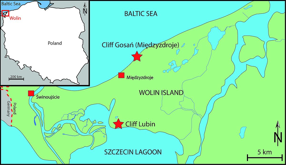
Island Wollin
„Vineta, Vineta, du rieke Stadt, Vineta sall unnergahn, wieldeß se het väl Böses dahn.“
[Vineta, Vineta, rich city, Vineta shall perish because she has done many evils.]
(from the Vineta legend)
According to the legend, these were the last words of the water woman, who let the city of Vineta be swallowed up by a huge wave. Vineta - a city full of wealth, pride and extravagance. It has not been historically clarified to this day whether it really perished near the today´s city of Wollin in north-western Poland. But 1,000 years ago, the city of Wollin on the island of the same name was still one of the richest cities - a Viking city with around 8,000 inhabitants called Julin, Jumne or Jomsburg is said to have existed.
"[...] the very famous city of Jumne offers a much-visited meeting point for Barbarians and Greeks in a wide area [...] It is really the largest of all the cities of Europe; Slavs live in it with other tribes, Greeks and Barbarians. Foreigners from Saxony have also received the same right of settlement, even if they are not allowed to publicly profess their Christianity during their stay. […] The city is filled with goods from all the peoples of the north, nothing desirable or rare is missing.”
(Adam of Bremen, 1080)
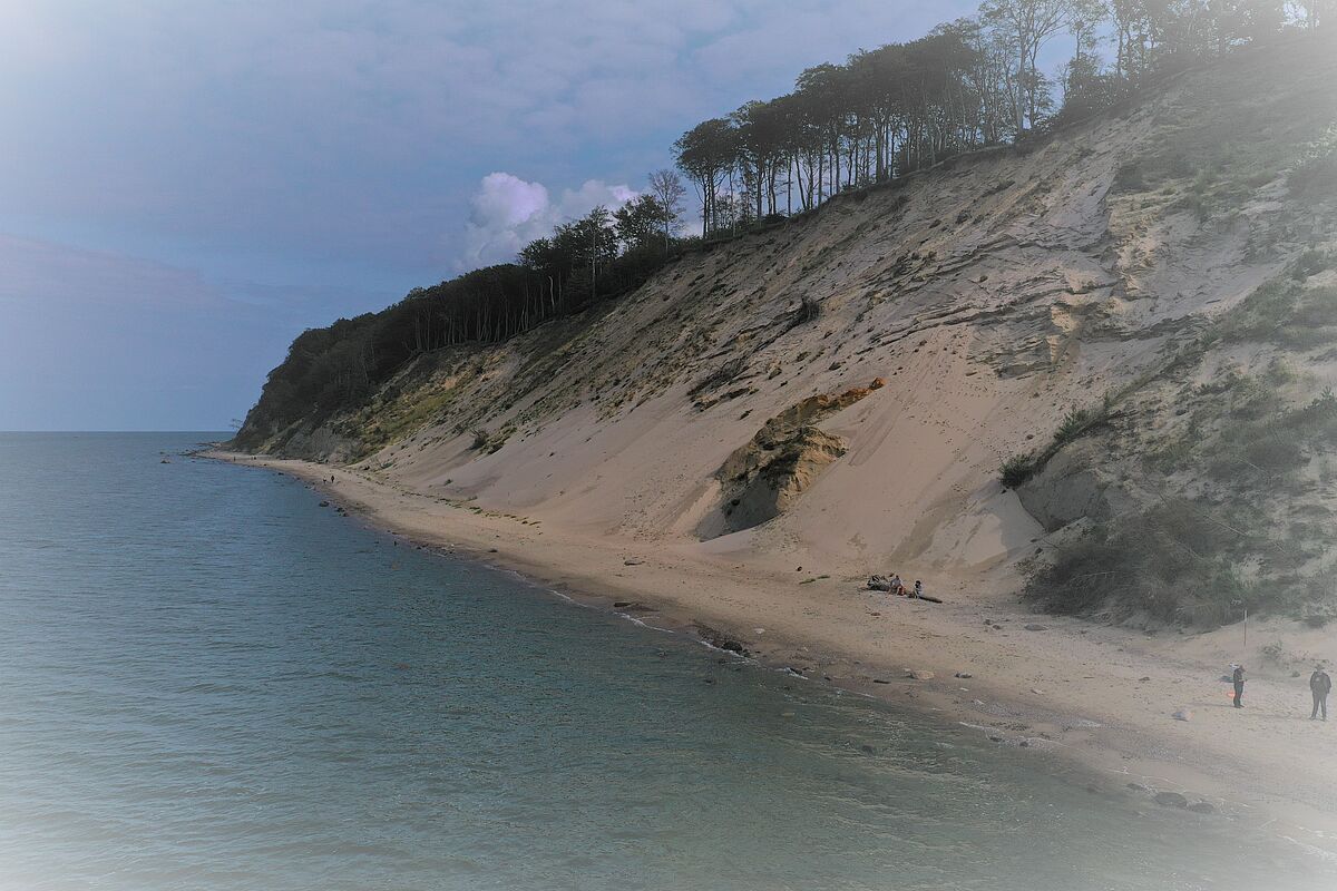
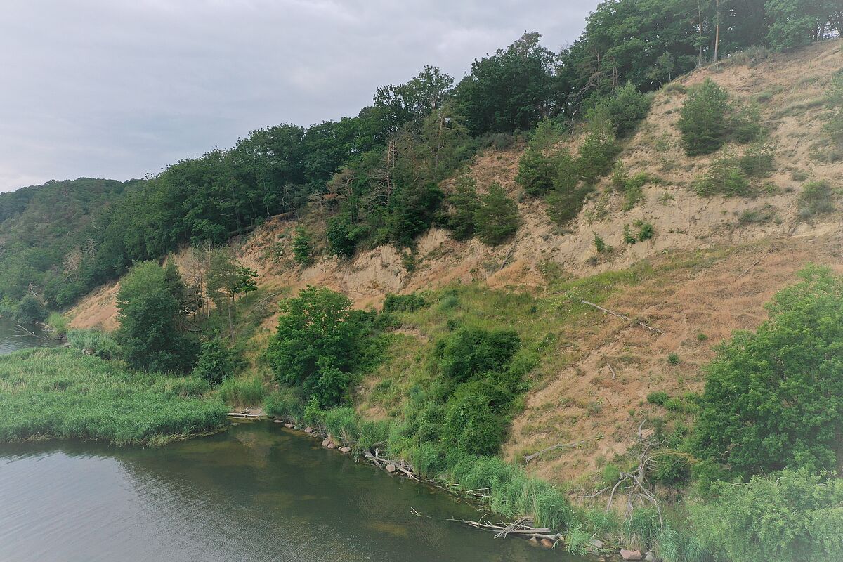
The steep coast of the Island of Wollin is decisive for the geomorphological and geological understanding. Sections of cliffs can be found both on the north side of the island (towards the Baltic Sea, e.g. Misdroy and Grodno) and on its south side (towards the Szczecin Lagoon, e.g. Lubin) and they provide important geo-archives that enable the reconstruction of the glaciation during the Pleistocene (2.6 million to 11,700 years before today) (Figs. 1, 2 and 3).
With a length of about 15 km, the cliffs of Wollin are part of a long zone of cliffs along the Polish coast (SUBOTOWICZ, 1982). The most striking landform is the Wollin terminal moraine, an elevation formed by the load and pressure of glaciers (KOSTRZEWSKI et al., 2015). In a paper by KRYGOWSKI (1959), the so-called glacitectonic character of the Wollin terminal moraine was confirmed. This means that this area was shaped by the tremendous pressure of the southern glacial lobes of the Scandinavian Ice Sheet. There were also numerous other studies, such as those by BORÓWKA et al. (1982, 1999) and KOSTRZEWSKI (1985) who dealt with the age sequence of the rock strata of the area. They described a series of two till units. In geology, till is understood as unsorted rock material with different grain sizes from clay to gravel to large blocks of rock, which was deposited by glacial ice. The lower part of the cliff north of Wollin (Misdroy, Grodno) is formed by a gray till, which is associated with the glaciation in the so-called Saale complex around 300,000 to 126,000 years ago (KOSTRZEWSKI et al., 2015). Above this lies the brown Vistula till of the Vistula glaciation (approx. 115,000 to 11,700 years before today), which is only slightly thick and exposed on isolated sections of the cliff. The glacial deposits are covered by up to 40 m thick sand layers deposited by meltwater rivers. These, in turn, are overlain by 2 to 15 m thick aeolian layers, i.e. sediments that were transported to this location by the wind (BORÓWKA et al. 1982).
For those who are particularly interested
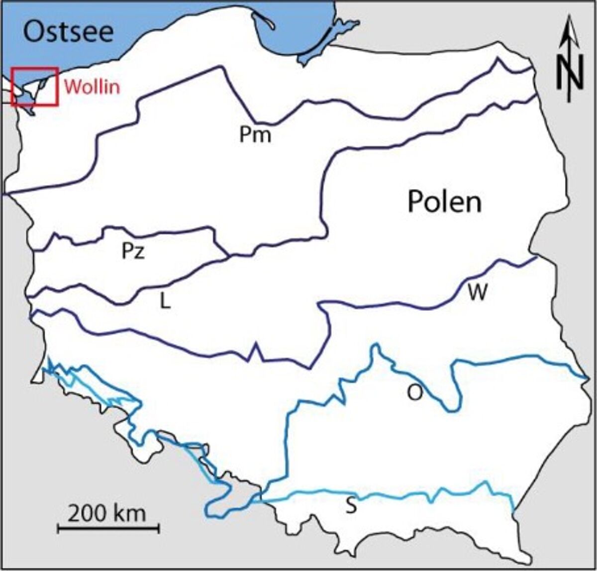
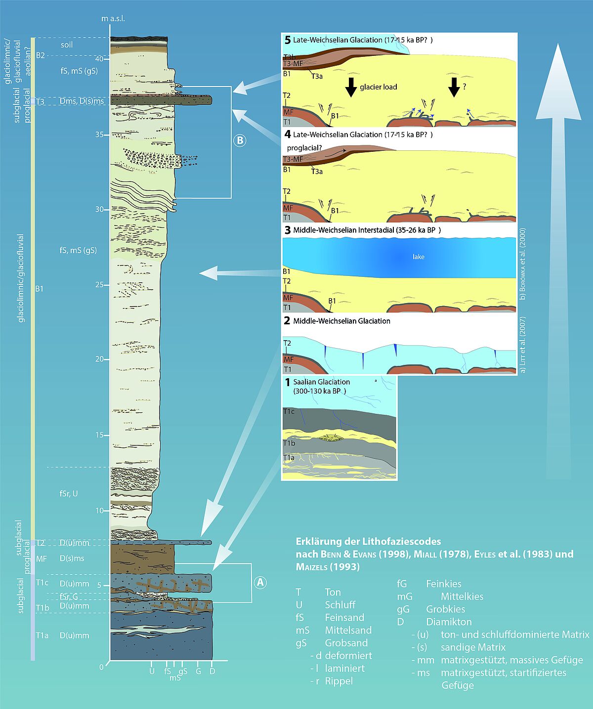

Poland's coast contains a variety of landforms and sediments: from Pleistocene moraines to Holocene dunes to inland lakes (KOSTRZEWSKI & ZWOLINSKI, 1986; 1988). In general, four main ice advances can be reconstructed in Poland using certain glacial landforms (Fig. 4; MARKS, 2004). The southernmost limit of Pleistocene ice extent in Poland dates from the Elster glacial 400,000 to 320,000 years ago (Sanian glaciation II; MARKS, 2004). The ice reached the Carpathians and the Sudetes at that time (MARKS, 2004). In southwestern Poland, this edge of the ice was overrun by the Odra ice sheet, which can be assigned to the Saale complex 300,000 to 126,000 years ago. The ice of the Warta glaciation also advanced in the Saale complex (cf. BARANIECKA, 1971). After a longer interglacial period (Eem interglacial, 126,000 - 115,000 years before today), the Vistula glaciation followed, divided into three glaciation phases (Leszno, Poznan, Pomerania), and introduced the so-called North Polish glaciation. The Eem period sediments were covered by several diamictic units (e.g. till), which can indicate different ice advances. In the Leszno phase, the ice in western Poland reached its maximum extent. This and the Poznan phase are assigned to the last glacial maximum (LGM). Some of the glacial lobes in the Polish area on the southern edge of the Scandinavian Ice Sheet have been described as rapidly advancing outlet glaciers (MARKS, 2004).
The island of Wollin is characterized by various morphological structures that are of glacial, glacial-fluvial, fluvial and marine origin. Furthermore, dunes and aeolian sediments characterize the image of the island. The characteristic Wollin mountains represent the 60 m high Wollin terminal moraine, which stretches from Misdroy, and Lubin to Świętouść. According to BOROWKA et al. (2000) it forms one of the youngest fringes of the last Polish glaciations, which formed between 15,500 and 14,200 years ago. It forms an arched ridge structure open to the east (RUSZCZYŃSKA-SZENAJCH, 1999).
The sedimentary succession of the Cliff of Gosań near Misdroy (Międzyzdroje, Baltic Sea coast) begins with Cretaceous marls, which were glacitectonically stacked with the Quaternary units (BOROWKA et al., 2000). Above this are grey-brown diamict sequences, overlain by a series of basin sands (Figs. 5 and 6, BOROWKA et al., 1999, GEHRMANN et al., 2014). It contains sandy-silty sequences interspersed with organic material and gravel. These are covered by brown diamicton near the top of the cliff (Figs. 5 and 6, GEHRMANN et al., 2014). The entire sequence is overlain by aeolian (?) sands with intermediate paleo soils.
There are two theories about the origin of the Wollin mountains:
(1) HARTNACK (1926), ZYNDA (1962), BRYL (1972) and BOROWKA et al. (1982) claim that the Wollin mountains represent a glacitectonic thrust complex.
(2) KRYGOWSKA & KRYGOWSKI (1965), KRYGOWSKI (1967) and RUSZALA et al. (1979) interpret these structures as kame plateaus. In this area, this means pre-vistulic glacial structures overlain by glacifluvial sediments.
The conclusion of BOROWKA et al. (2000) that the recent sedimentary succession represents a late-glacial aeolian cover indicates that they must be young glacitectonic formations. This contradicts the theory of kame plateaus.
References
[Translate to English:]
Baraniecka, M.D. (1971): The Widawka drainage basin as part of the marginal area of the Mazovian-Podlasie (Warta). Stadial in Poland. - Biuletyn Instytutu Geologicznego: 11–36.
Borówka, R. K., Gonera, P., Kostrzewski, A., Zwoliński, Zb., (1982): Origin, age and paleogeographic significance of cover sands in the Wolin end moraine area, North-West Poland. Quaestiones Geographicae 8, 19–36.
Borówka, R. K., Goslar, T., Pazdur, A., (1999): Wolin End Moraine: age of glacitectonic structures in the light of lithostratigraphic data and radio-carbon dating. – In: R. K. Borówka, Z. Młynarczyk, A. Wojciechowski (eds.): Ewolucja geosystemów nadmorskich południowego Bałtyku. Bogucki Wydawnictwo Naukowe, Poznań-Szczecin, 43–47.
Borówka, K., Goslar, T. & Pazdur A. (2000): Age of Glaciotectonic Structures on the Wolin island in the light of lithostratigraphic data radiocarbon dating. Journal on methods and applications of absolute chronology. - Geochrometria: 35–40.
Bryl, A. (1972): Spostrzezenia nad zaburzeniami w glinie morenowej klifu morskiego w Grodnie na Wolinie [Remarks about disturbances within glacial till building the marine cliff in Grodno, Wolin Island]. – Badania Fizjograficzne nad Polska Zachodnia: 61–73.
Gehrmann, A., Lenk, J., Rother, H. (2014): Middle and Upper Pleistocene glacial deposits on Wolin Island (NW Poland) – New results from mapping coastal cliff sections east of Międzyzdroje. – Joint Conference GeoFrankfurt 2015 Earth System Dynamics, 21.09.-24.09.2014, Frankfurt.
Hartnack, W. (1926): Die Küste Hinterpommerns unter besonderer Berücksichtigung der Morphologie. Jahrbuch der Geographischen Gesellschaft Greifswald 43/44, II Beiheft:1-324.
Kostrzewski, A., (1985): Variation in the particle-size distribution and degree of sand grain abrasion in morainic till of the Wolin Island, NW Poland. Quaternary Studies in Poland 6, 83–97.
Kostrzewski, A., Zwoliński, Zb. (1986): Operation and morphologic effects of present-day morphogenetics processes modelling the cliffed coast of Wolin Island, N.W. Poland. In V.Gardiner (Ed.), International Geomorphology 1986, John Wiley and Sons, Pt 1, 1231– 1252.
Kostrzewski, A., Zwoliński, Zb. (1988): Morphodynamics of the cliffed coast, Wolin Island. Geographia Polonica 55, 69–81.
Kostrzewski, A., Zwoliński, Z., Winowski, M., Tylkowski, J., Samołyk, M. (2015): Cliff top recession rate and cliff hazards for the sea coast of Wolin Island (Southern Baltic). Baltica 28(2), 109-120.
Krygowski, B., (1959): O związkach rzeźby dzisiejszej powierzchni ze strukturą podłoża na Pomorzu Szczecińskim [About connections of contemporary relief with the base structure of Szczecin Pomerania]. Zeszyty Naukowe Uniwersytetu im. Adama Mickiewicza, Geografia 2, 69–86.
Krygowska, L. & Krygowski B. (1965): Kilka spostrzezen dotyczacych struktury klifu w Grodnie na Wolinie [Remarks about geological structure of cliff at Grodno, Wolin Island]. – Badania Fizjograficzne nad Polska Zachodnia: 167–170.
Krygowski B. (1967): Wazniejsze problemy plejstocenu Polski Zachodniej [Main problem of West Poland Pleistocene]. – Czwartorzęd Polski, 167–205, Warszawa.
Marks, L. (2004): Pleistocene glacial limits in Poland. – In: Ehlers, J. and P.L. Gibbard, P.L. (eds.): Quaternary Glaciations — Extents and Chronology, 295–300 (Elsevier).
Ruszczyńska-Szenajch, H. (1999): Direction of the last ice sheet advance in the polish Baltic coast recorded by glaciotectonic structures and landforms. - Quaternary Studies in Poland, 195–202.
Subotowicz, W., (1982): Litodynamika brzegów klifowych wybrzeża Polski [Lithodynamics of Polish cliff-coast]. Gdańskie Towarzystwo Naukowe, Ossolineum, Wrocław, 150 pp.
Zynda, S. (1962): Byniki wstepnych badan nad morena czolowa wyspy Wolin [Results of preliminary investigations of end moraine of Wolin island]. - Badania Fizjograficzne nad Polska
Zachodnia: 159–168.